By studying and observing the oceans, such as sea height, we can understand our planet’s climate change and safeguard the marine ecosystems. Observation satellites have become indispensable in obtaining this information. The camera and radar images and raw data provided by the sensors, several hundred kilometres from the surface, must be processed before use.
With its experience in Space Big Data and data processing, ALTEN collaborates with large companies in the field. But how do the raw data collected by observation satellites become usable? ALTEN offers an in-depth look at this.
Observation of the oceans: choosing and recovering data
To study the behaviour of the oceans, scientists use satellites in two ways.
- The first method is to take data readings from space. In this case, the satellites are placed in sun-synchronous orbit (altitude between 35 and 786 km) and are equipped with photographic sensors or radars. This allows them to collect raw “images” by flying over the oceans at regular intervals. Once these images have been obtained, the satellites transmit them to the ground stations.
- The second method is called “in-situ measurement”: The satellite is then only a relay between an offshore measuring device and the data collection centre. For this purpose, ocean study organisations have networks of communicating buoys and beacons in the areas to be studied. They are equipped to measure parameters such as water temperature or salt content. The results are then transmitted by a satellite link.
The data recovered by the ground stations cannot be used. During the collection by the satellites, numerous factors corrupt the data, such as the atmosphere, the evolution of the satellite position, and clouds. The data must therefore be processed to correct the effects of disturbances occurring during the satellite’s second acquisition.
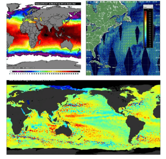
Data collecting by satellites with radars, scatterometers, and altimeters
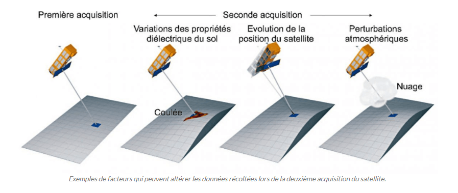
Examples of factors that may corrupt the data collected during the satellite’s second acquisition.
How are satellite images processed?
Converting the raw data obtained by the satellites into data available to customers requires a data processing chain procedure. In this sense, the processing systems are standardised by the various space agencies according to the CEOS standard and described in several levels:
- Level 0 : the data are reconstructed but not processed. They are provided by the network of satellites in full resolution and accompanied by all the information necessary for higher-level processing.
- Level 1 : all the pixels were acquired on the same date during a passage of the satellite. The processing makes no hypothesis about the observed environment. Each pixel of the image is processed in the same way. The product expresses the data in physical scale.
- Level 2 : the data must also be acquired in a few moments. But this time, types of processing differentiated by pixel type are permitted. It is possible to make assumptions about the atmosphere, the state of the sea, the reflections of the sun, or the relative rotation of Earth to correct the images.
- Level 3: in this case, the product consists of data acquired on different dates. The images can be retouched in the same way as described in level 2 and can be merged to correct for climatic disturbances. They are generally periodic summaries (weekly, 10-day, monthly) of the data obtained at level 2.
- Level 4 : these are the model outputs or the results of the lower-level data analyses. In other words, these are variables that are not directly measured by the instruments but are derived from them. For example, with ocean height data, the location of ocean currents can be deduced.
Several teams of engineers must then work to process all this information.
- A first team is in charge of implementing algorithms (smoothing, linear interpolation), which, starting from an imprecise image, correct it to make it usable.
- A second team is responsible for verifying the location and the angle of information acquisition of the satellites. Since the satellites move around the Earth at high speed, there may be uncertainty about their location.
- A final team analyses the obtained measurements such as salt content, ocean level, or whirlpools and makes the studies available to customers.
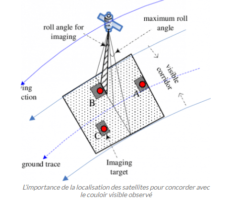
The importance of satellite location to match the observed visible corridor.
What are the scopes of these measures?
Ocean observation data are of paramount global importance for economic, environmental, and social development.
- Economical: since they are used, for example, to define and study fishing areas. In particular, the globalfishingwatch.org map was developed using satellite data. This tool tracks all fishing vessels in the world’s oceans in real time. It is also possible to monitor maritime areas and their state of exploitation or overexploitation for 90% of fishing areas.
- Ecological: since the study of ocean levels is one of the primary factors used to describe the state of global warming. And one of the gains brought about by the action of satellites is precisely their ability to observe the impact of humans on marine ecosystems and detect hydrocarbon degassing. This action is all the more essential when we know that in 2019, for example, satellites made it possible to monitor the evolution of the oil spill caused by the sinking of the Grande America cargo ship or that more than a million people live within 500 metres of the coasts in mainland France – a proportion that even amounts to 16% globally.
- Social: since satellites are key tools in ocean observation and the study of marine weather phenomena. In addition to providing regular information useful for weather forecasting, they are also used to study extreme events such as tsunamis. In this case, they can relay the first warning signals emitted by the “DART” buoys at sea or else make it possible to accurately study the propagation and intensity of seismic or other waves.
Another satellite monitoring role was highlighted with the Kevin Escoffier incident in 2020. The sailor was participating in the Vendée Globe when he sent out a distress signal. Thanks to the beacon on his boat, the skipper was quickly located and rescued. These beacons have become mandatory for pleasure craft and use the satellite network to operate.
For all these reasons, ocean observation and the reliability of satellite data are critical issues. The key to developing these activities lies around a need for faster, more reliable data processing, even as the incoming data flow grows. Experts are focusing in particular on the development of new artificial intelligence algorithms to meet these requirements.